Global navigation satellite systems (GNSS) enable widespread access to accurate navigation and timing. These are used, directly or indirectly by almost every sector, from farming and finance, to navigation in cars and planes. A common example of GNSS being used in everyday life is in sat nav (satellite navigation) systems which most people have on their mobile phone devices and cars.
GNSS is made up of three segments:
- Space Segment
The space segment is made up of the satellites which orbit the earth and broadcast signals containing the satellite’s time, orbit, and status.
2. Control Segment
The control segment consists of a master control station which adjusts the satellite’s orbits and time to maintain accuracy and monitor stations which collect the relevant information from the satellites to relay to the master station.
3. User Segment (REF-01: Jeffrey, 2010)
The user segment is the equipment which processes signals from the satellites to derive location and time information.
GNSS constellations
GNSS is the term used to describe any satellite system, of which there are multiple. For example: Global Positioning System (GPS) which was launched in the 1970s by the US department of defence, Galileo operated by the European Union and BeiDou which is Chinese.
RF Bands
Of the different GNSS constellations (eg. GLONASS, Galieo, GPS etc) they each transmit signals at different frequencies. One advantage of multiple frequencies is that receivers can use two different ones to minimize errors created by transmission through the atmosphere (REF-02: Badran, 2022).
The L-band refers to frequencies in the radio spectrum from 1 to 2 GHz (1000-2000 MHz), which is the top of the ultra-high frequency (UHF) spectrum, to the lower of the microwave range. The GPS constellation transmits at three frequencies: L1, L2 and L5 which are within the L-band.
| RF Band | Frequency | |
| L1 | 1575.42 MHz | This is the original GNSS band. L1 is used for navigation which is done by tracking GPS satellite location from the information provided by the signal (REF-03: Barratt, 2021). L1 is still broadcast by satellites and often used due to the equipment to detect it being cheap and easily available. It is however considered a more legacy RF band, eventually to be phased out in favour of other frequencies. |
| L2 | 1227.60 MHz | The frequency for L2 is lower than that of L1 which permits the signal to pass through obstacles such as cloud cover, trees, and buildings more effectively (REF-04: GIS Resources, 2022). As part of the modernisation of GPS, the L2 band now includes L2C which is a civilian signal offering improved navigation accuracy and an easy-to-track signal. L2C can also act as a redundant signal in case localized interference makes the L1 band unusable (REF-05: GPS.gov, 2020). |
| L5 | 1176.45 MHz | The L5 RF band has higher transmission power and enhanced signal architecture compared to other GPS signals and was introduced to improve current performance. The signal is projected to provide a high gain in processing, in part due to its bandwidth. It’s practical use is to improve accuracy for civilian use such as aircraft precision approach guidance (REF-01: Jeffrey, 2010). |
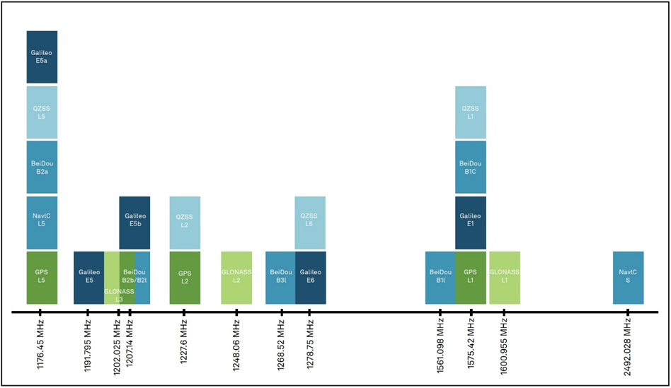
The three signals transmitted by GPS satellites, as well as those available from different constellations are shown in Figure 1.

Figure 1 (Jeffrey, 2010)
GNSS Jamming
Receivers can be denied from detecting signals from a GNSS satellite due to interference. Signals can also be blocked by non-intentional activity, called interference.
If the cause of the blocked signal is intentional, it is termed jamming, and jammers are the devices which achieve this. Because GNSS operates at low power it makes interference relatively easy. If a jamming signal is projected at the same frequency and a higher power, the GNSS signal cannot be detected so the information contained within it cannot be transferred or collected (REF-06: McCrystal 2018).
Another type of intentional interference is spoofing, where a signal mimics a GNSS satellite signal is broadcast at power higher than the actual signal. This causes the receiver to report an incorrect position.
References
| ID | Reference | Description | URL |
| REF-01 | Jeffrey, C. (2010) | An introduction to GNSS : GPS, GLONASS, Galileo and other Global Navigation Satellite Systems. Calgary: Novatel. | Available at: https://novatel.com/an-introduction-to-gnss |
| REF-02 | Badran, B. (2022) | Navigating the L1, L2 and L5 Band Options for GNSS. [online] Everythingrf.com. | Available at: https://www.everythingrf.com/community/navigating-the-l1-l2-and-l5-band-options-for-gnss [Accessed 28 Jun. 2023] |
| REF-03 | Barratt, K. (2021) | Explaining the Different Types of GPS Signals: L1 C/A & L1C – GTT Wireless. [online] GTT Wireless. | Available at: https://www.gttwireless.com/explaining-the-different-types-of-gps-signals-l1-c-a-l1c/ [Accessed 28 Jun. 2023] |
| REF-04 | GIS Resources (2022) | Everything You Need To Know About GPS L1, L2, and L5 Frequencies. [online] GIS Resources. | Available at: https://gisresources.com/everything-you-need-to-know-about-gps-l1-l2-and-l5-frequencies/ [Accessed 28 Jun. 2023] |
| REF-05 | GPS.gov (2020) | GPS.gov: New Civil Signals. [online] www.gps.gov. | Available at: https://www.gps.gov/systems/gps/modernization/civilsignals/ |
| REF-06 | McCrystal S. (2018) | Detecting and Defeating GPS Jamming. The Maritime Executive; 2018. | Available from: https://maritime-executive.com/blog/detecting-and-defeating-gps-jamming |


